
Project Description
Itinerary
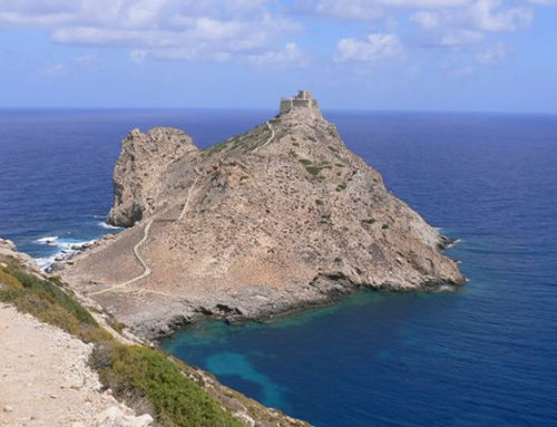
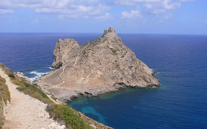
Itinerary 1: Country – Castello di Punta Troia
Challenging 1.5 h. about
Starting from the old direction (N), you reach the promontory of Punta Troia, on which the castle stands. The path, which winds under the mountain, overlooks the right with spectacular cliffs over the sea and finally, past the camel rock, descends towards the isthmus that joins the promontory of Punta Troia to the rest of the island. Pay close attention to the final part of the route because it is steep and alternates between very steep and slippery slopes and descents. (Egadi Perle del Mediterraneo pages 86-87)
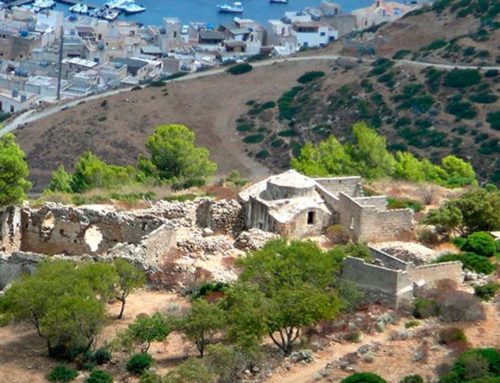
Itinerary 2: Country – Roman Houses – Monte Falcone
Easy about 2 hours
It starts from the old port in the direction of Roman houses. Going along a paved path you go up to the so-called Roman Houses, near which there is a spring. Continue north-west, passing at the foot of Punta Campana (q. 630 m) and bypassing the Pizzo del Capraro (q. 627 m), to then arrive at monte Falcone q. 686 m, from which you can enjoy a beautiful view of both sides of the island. Incredible scenery but beware of the clouds that often hit the mountain in the morning from N.
Itinerary 3: Country – Punta Basano
Challenging about 1 hour
It starts from the village in a southerly direction, after the cemetery you will find the indication for Punta Basano after about 300 meters. Following the path you reach the saddle at an altitude of 112 m where you can admire the view of the west, the path continues reaching another saddle at 150 m, continuing south finally you arrive at the highest point at 183 m. The last stretch is quite bumpy and requires adequate shoes.sent on the archipelago.
Itinerary 4: Country – Carcaredda – Punta Libeccio
Easy about 2 hours
From Marettimo go along the road that leads south east towards the cemetery until you reach a crossroads indicating Carcaredda and Punta Libeccio. Arriving at the Carcaredda you can make a brief stop near a forest shelter. The trail continues to the south west of the island and after a downhill path you arrive at the lighthouse and then at Punta Libeccio where you can go for a swim in the beautiful Cala Nera.
Itinerary 5: Country – Carcaredda – Semaforo
Easy about 3 hours
From Marettimo go along the road that leads south east towards the cemetery until you reach a crossroads indicating Carcaredda and Punta Libeccio. The trail climbs westward through a low pine forest and with numerous turns it soon gains altitude up to Carcaredda where it is possible to make a brief stop near a forest shelter. Leaving the pine forest going up you reach the collar between Punta Ansini and Punta Semaforo, turning right you arrive at the top of the Semaforo. Returning to the collar you can take the path that, descending to the right of the island, takes us back to Case Romane and finally to Marettimo.
Itinerary 6: Country – Cala Bianca
Very demanding about 2.5 hours
From the Scalo Vecchio take the path to Punta Troia direction (N), until the junction for Cala Bianca. Going through some downhill bends, you reach the most dangerous section, where the path is reduced to a thin trail; after a smooth path again, you reach the Punta Mugnone promontory, from which it is possible to see 60m below Cala Bianca. The very demanding excursion in the last stretch, requires a sure step and exposure habit, where mistakes are not allowed. Being exposed to the North, it is practicable with the Scirocco wind, but absolutely not advisable with gusts of Maestrale.


